Panama's Mountain Range
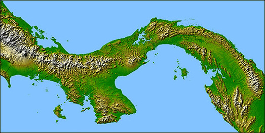
Panama mountain communities stretch the entire country. When most people think of the Americas, they think North to South. Panama’s unique geographical position is such that the country and its mountain range run west to east. The western border neighbors with Costa Rica and the eastern with Columbia.
Over the last 10 years there have been lots of articles and blogs about Panama being one of the best places to retire, they’re generally referring to one of Panama’s picturesque mountain communities. This site will give you information about the mountain communities that line Panama’s mountain range from west to east.
Above you will find four tabs; Chiriqui, Veraguas, Cocle and Panama, representing the provinces from West to East, excluding the provinces of Bocas del Toro and Darien. Each Province has subtabs that include the mountain communities located in that province. Chiriqui has Volcan and Boquete. Veraguas has Sante Fe. Cocle has La Pintada Santa Rita and El Valle de Anton. Panama has La Laguna, Sora, Chica and Cerro Azul.
The dominant feature of the country's landform is the central spine of mountains and hills that forms the continental divide. The divide does not form part of the great mountain chains of North America, and only near the Colombian border are there highlands related to the Andean system of South America. The spine that forms the divide is the highly eroded arch of uplift from the sea bottom, in which peaks were formed by volcanic intrusions.
The mountain range of the divide is called the Cordillera de Talamanca near the Costa Rican border. Farther east it becomes the Serranía de Tabasará, and the portion of it closer to the lower saddle of the isthmus, where the canal is located, is often called the Sierra de Veraguas. As a whole, the range between Costa Rica and the canal is generally referred to by geographers as the Cordillera Central.
The highest point in the country is the Volcán Barú (formerly known as the Volcán de Chiriquí), which rises to 3,475 meters (11,401 ft).
